UBC-GIF
Set of programs for 3D geophysical modelling and inversion.
"Advanced geophysical modelling and inversion programs that include solutions for: Gravity and Magnetic Gradient Data, Resistivity and Induced Polarization, and Electromagnetics."
Director, Xpotential Geoscientific Consulting
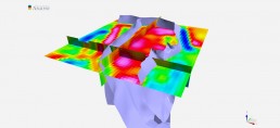
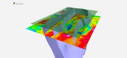
UBC-GIF designates a set of Industry-standard advanced geophysical modelling and inversion programs. 3D modelling and inversion programs for gravity and magnetic gradient data, resistivity and induced polarization, and electromagnetics are included. The programs were developed by the University of British Columbia Geophysical Inversion Facility as stand-alone, but they can be used within Geoscience ANALYST Pro Geophysics and GOCAD® Mining Suite as well. Many of the codes can be run directly from Geoscience ANALYST’s GIFtools utility, thus providing an extensive system of user interfaces to set up, execute, and interpret the results of the advanced geophysical forward modelling or inversion. They may also be run directly from GOCAD workflow interfaces for organizing and documenting process flow, as well as facilitating the incorporation of geological constraints.
The price of the license depends on the version and geophysical software selection that suits your individual needs best. Academic and non-profit licensing is available as well.
Gravity and Magnetic Gradient Data
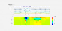
GRAV3D library allows you to carry out forward modelling and inversion of surface, airborne and/or borehole gravity data in 3D. The forward modelling uses an integral equation approach on a tensor grid computing and storing the (possibly compressed) sensitivity matrix. The inverse problem is then solved as an optimization problem minimizing the earth structure, provided that the data are adequately fitted and additional specified constraints are honoured, such as geological constraints that may be directly communicated from GOCAD Mining Suite models.
MAG3D library allows you to carry out forward modelling and inversion of surface, airborne and/or borehole magnetic data in 3D. Arbitrary combinations of field components in borehole, surface, and airborne surveys can be inverted simultaneously. The forward modelling uses an integral equation approach on a tensor grid computing and storing the (possibly compressed) sensitivity matrix. The inverse problem is then solved as an optimization problem minimizing the earth structure, provided that the data are adequately fitted and additional specified constraints are honoured, such as geological constraints that may be directly communicated from GOCAD Mining Suite models.
Resistivity and Induced Polarization
DCIP2D helps you carry out forward modelling and inversion of direct current (DC) resistivity and induced polarization (IP) data in 2D. It is possible to invert all linear survey surface-array types, including non-standard or uneven arrays. It is compatible with dipole-dipole, pole-dipole, and pole-pole arrays. Wenner, Schlumberger, gradient and other arrays can all be inverted. Finite volume techniques on a tensor grid are used for the forward modelling of the DC resistivity. The inverse problem is then solved as an optimization problem minimizing the earth structure, provided that the data are adequately fitted and additional specified constraints are honoured, such as geological constraints that may be directly communicated from GOCAD Mining Suite models.
DCIP3D helps you carry out forward modelling and inversion of DC resistivity and IP data over a 3D distribution of electrical conductivity and chargeability. The library works with the data acquired from general electrode configurations and arbitrary observation locations either on the earth’s surface or in a borehole. 3D surface topography is as well fully incorporated in the modelling and inversion. Finite volume techniques on a tensor grid are used for the forward modelling of the DC resistivity. The inverse problem is then solved as an optimization problem minimizing the earth structure, provided that the data are adequately fitted and additional specified constraints are honoured, such as geological constraints that may be directly communicated from GOCAD Mining Suite models.
Electromagnetics
EM1DFM can invert any type of geophysical frequency-domain loop-loop electromagnetic (EM) data with the aim of finding one of four types of 1D models, with one of four variations of the inversion algorithm. It is possible to have many permutations of model type, data type, and algorithm choice. The inverse problem is solved as an optimization problem minimizing the earth structure provided that the data are adequately fitted and additional specified constraints are honoured, such as geological constraints that may be directly communicated from GOCAD Mining Suite models.
EM1DTM can invert geophysical time-domain EM data (B or dB/dt) from inductive sources to recover a 1D conductivity model of the earth. It is possible to vary the model objective function to provide models ranging from ‘smooth’ to ‘blocky’ in accordance with the assumed geology. Variable strategies to estimate the trade-off parameter to balance the model structure and data misfit are provided. The program runs using an interface that makes it possible for multiple soundings to be stitched together, forming a profile. The inverse problem is solved as an optimization problem minimizing the earth structure provided that the data are adequately fitted and additional specified constraints are honoured, such as geological constraints that may be directly communicated from GOCAD Mining Suite models.