VP Geophysics Suite
Suite of programs for potential field and time-domain electromagnetic data interpretation through geologically-based forward modelling and inversion.
“VPmg and GOCAD Mining Suite allows the construction of plausible geological model for which concepts on single cross-section would not have been tenable.”
Mark DuffettSenior Geophysicist at Mineral Resources Tasmania
The group of modelling programs designed for 3D modelling and inversion of gravity, gravity gradient, total magnetic field, magnetic gradient, and time-domain electromagnetic data is VP Geophysics Suite. It allows stand-alone use, integration within GOCAD® Mining Suite, or use with Geoscience ANALYST. VP Geophysics Suite models are geologically-based—they work directly with geological contact geometries as well as physical property distributions within geological units. This model parameterization lends itself to a variety of forward modelling and inversion applications.
The license price depends on the selection of programs that best fits your individual needs. Academic pricing is also available.
Geophysical modelling
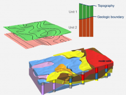
The discretization scheme adopted in the VP algorithms divides the 3D earth into tightly packed Vertical Prisms containing geological boundaries separating individual packages of rock. Each model cell knows both its rock type and physical properties. This allows one to think in terms of geologic domains. The number of geological domains from prism to prism can vary and this allows for full 3D geological complexity. Unconstrained inversions can also be performed using VP Suite.
- Geometric weights near pierce points and fixed layers
- Fixed properties at, and added weighting near to, drillholes (exert a radius of influence around the drillhole)
- Select which lithologies are adjusted and which are fixed
- Upper and lower property bounds per lithology
- Conventional 3D property inversion
- Apparent density/susceptibility/conductivity
- 1D AEM
- Geobody
- Depth to basement
- Versatile and compact
- Supports a variety of model styles
- Facilitates a variety of inversion styles
- Local models can be incised into regional models
- Topography explicitly incorporated into the model due to arbitrary cell thickness
- Homogeneous or heterogeneous lithologic units
- Each cell knows rock type and property allowing a variety of inversion options
- Specific control over inversion
- Inversion can operate directly on a geological model geometry by deforming 3D contacts
Forward modelling and inversion styles
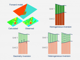
You can test your existing geological model against geophysical data for geological model evaluation and validation using VP forward modelling. A wide variety of model styles is supported under the model parameterization, which in turn facilitates a variety of inversion styles. Domains can be homogeneous, have simple lateral variations, or full 3D heterogeneity within a singe model. Remanence and self-demagnetization may be incorporated in susceptibility models.
- Quantitatively test geological concepts
- Validate geological models
- Model remanence and/or self-demagnetization
- Computes true TMI
- Terrain correction
- Cover correction
- Regional modelling and incorporation of regional fields
- Discrete domain modelling
- Geological data defines starting model
- Depth to basement
- Geobody inversion
- Soft and hard constraints can be incorporated
- Homogeneous domain optimization
- Bounded properties
- Recover remanent magnetization direction
- Invert TMG or magnetic amplitude data
- Heterogeneous property inversion
- Discretize domains internally
- Invert for 3D property variations within domains
- Solve for lateral property variations to recover apparent density or susceptibility
- Discretize vertical cells to be constant or variable
- Allows for conventional unconstrained inversion
Applications of VP models
VP models are flexible enough to support a wide variety of applications that go beyond simple unconstrained inversion.
- Compute data from terrain models to generate the response and correct data
- Apply response from layers of transported cover/regolith
- Use density or density contrast values for gravity and gravity gradiometry data
- Test existing geologic models
- Compute the response of simple or complex 3D wireframes and compare to measured data
- Quickly run multiple simulations, varying depth extent, dip, and physical property
- Invert for basement geometry for AEM, gravity, and magnetics
- Guide the model with geological constraints or begin with a simple two-layer model
- Ideal for greenfield projects
- Allow for simplified lateral variation in the basement
- Apply to any geological contact that exhibits a prominent rock property contrast (e.g. top of limestone, basalt dome modelling)
- Output is a geological surface
- Assign magnetic remanent parameters to geological domains
- Invert for the bulk property remanent parameters: orientation and intensity (Q-ratio)
- Utilize data that is weakly dependent on remanent magnetization: total magnetic gradient or magnetic amplitude
- Modelling uses the true TMI
- Invoke self-demagnetization in forward modelling and inversion that models the interactions between high-susceptibility cells
- Derive a volume explaining the geophysical response
- Initialize from depth estimation, prior information, or begin as a zero-thickness layer
- Represent body as a geologic unit with its own property, bounds, and magnetization parameters
- VP models live within an inclosing half space rather than a vacuum
- Incise local models into regional models, explicitly taking the regional response into account
- Minimizes edge effects
- Regional models are VP models that can vary in complexity
- Rotate models to assess the results directly in real world coordinates
- Data rotation is performed internally and does not need to be done by the user
- Optimize model mesh for surveys that have oblique layouts or line orientations
Potential fields and EM data
VPmg program: It is a program for 3D modelling and inversion of gravity, gravity gradient, TMI, and magnetic gradient data. Its constraints include pierce points on drilled contacts and downhole measurements of physical properties. Geological models are generated by assigning each cell to a geological unit. Geometry of contacts, as well as density or magnetic susceptibility of geological units can be adjusted via inversion. In each geological unit, it is possible to have homogeneous or heterogeneous density or magnetic susceptibility. Multiple ways are offered in VPmg for handling remanent magnetization through direct inversion of remanent magnetization parameters and inversion of derived data types.
- Data reduction (e.g., gravity terrain correction, overburden stripping)
- Depth to basement inversion
- Rapid, accurate terrain modelling for gravity
- Can embed a local model into a regional model to account for regional effects
- Model and invert total-magnetic gradient or magnetic amplitude data
- Modelling and inversion with self-demagnetization
- Data options for gravity include: free-air or terrain-corrected data; ground, airborne or sub-surface gravity; gradiometry (any or all tensor components, plus FALCON Guv/Gne)
- Data options for magnetics include: models true TMI; gradiometry (any or all tensor components, plus TMG); vector magnetics; magnetic amplitude; airborne, ground or sub-surface
Vpem1D program: It allows 1D time-domain electromagnetic inversion in a 3D geological framework, which facilitates a variety of inversion styles. To determine optimal conductivities, homogeneous unit inversion can be used when one or more geological units are considered uniform; when there are conductivity variations within units, heterogeneous unit inversion is applied. It is possible to use geometry inversion for the adjustment of interfacial depths (e.g., depth to basement).
- Designed for inverting moving loop data from airborne central loop and Slingram configurations
- Horizontal (along-line) or vertical B-field or dB/dt data can be inverted
- During inversion, each vertical prism is treated as a layered model and the conductivity or geometry of active cells in the model is adjusted to reproduce the observed data
- Each vertical prism is inverted in 1D within the context of the 3D VP model
- Multi-moment transmitter systems can be inverted
- Data options include: B-field and dB/dt, X, and Z; variety of slingram and moving loop systems
VPem3D program: This is a fast approximate 3D modelling and inversion program for airborne, ground, and downhole time-domain electromagnetic data. Although it has been designed for geologically-constrained inversion, VPem3D is also suitable for unconstrained inversion. It is possible to adjust geometry of contacts, as well as conductivity of geological units via inversion. In each geological unit, the conductivity can be heterogeneous or homogeneous.
- VPem3D converts TEM decays to resistive limits in order to reduce run times by a factor of 10 or more relative to conventional programs
- VPem3D can invert 3-component moving loop or fixed loop B-field or dB/dt data for virtually any configuration
- Data options include: airborne, ground, and down hole EM time domain systems; X,Y, Z
VPutility program: It is a free program to help you for the creation and modification of VP models. It is compatible with all VP Geophysics Suite products. It can add constraints from drillhole pierce-points on contacts. It is possible to add geological layers simply with ASCII-based files. Heterogeneous cell models are created. Any VP model and its data can be written to a Geoscience ANALYST project file for visualization and communication in 3D.
- Creates layered-earth VP models
- Layers can be added to build subsurface modelling complexity
- Exports VP models to Geoscience ANALYST
- Information printout on an existing VP model